

Since 1964, Paleo-Data has provided high-resolution foraminifera and calcareous nannofossils biostratigraphic data and expertise, encompassing Jurassic through Quaternary.
Following the acquisition of Paleo-Data in 2022, these trusted datasets and services are now fully integrated into PetroStrat’s global geoservice offerings.
We deliver fully innovative multidisciplinary geoscience service packages, of which the Paleo Data biostratigraphic is now a core component. We combine that legacy data with our own global expertise in reservoir geology, laboratory services, biostratigraphy and exploration support. Our comprehensive approach is adaptable, we tailor our service bundles to meet the unique and evolving needs of our client’s ensuring success in the dynamic energy and exploration landscape. We provide quality data to power data driven insights and maximise the success of your subsurface operations.

Our US branch, registered as PetroStrat Inc., is now the custodian of the Paleo-Data products. Our dedicated North America team are based in Houston, TX, and Mandeville, LA , to accommodate and serve the specific stratigraphic needs of this area.
Explore USA Paleo-Data Products
- Offshore Gulf of Mexico Paleo Database
- GOM Basin Paleoenvironmental Well Geohistory and Sequence Map Sub-Database
- Individual Biostratigraphic Well Reports
- Clearing House

We provide comprehensive reports and interpreted datasets for all released Offshore Northern Gulf of Mexico wells originally worked at Paleo-Data. Additionally, we also provide reports on summarise public data (BSEE).
In total, we have a library of more than 12,000 well detail reports.
For all reports, we provide standardised frameworks for bioevents, horizons, tops, and ecozones. By utilizing a single-source, we ensure consistency across all reports and projects.

The sub‐database enhances the 2015 Gulf of Mexico chronostratigraphic sequence and deposystem maps database. It includes detailed deposystem maps for each of the 46 Cenozoic Gulf of Mexico Chronostratigraphic Sequences, providing critical support for reservoir risk assessments.
Key map types:
- Paleobathymetric Ecozone Sequence Maps
- Lithobiofacies Sequence Maps
- Lithobiofacies maps go a step beyond paleoecozone maps, capitalizing on the dual utility of many foraminiferal paleoecozone index taxa. The identification, mapping and analysis of lithobiofacies provide unique qualitative insights into the distribution of reservoir section through time.
- Estimated Sand Percentage & Estimated Sand Gross Maps
- Another important component of the regional reservoir risk assessment tool kit. These maps show the spatial distribution of sand-rich vs. sand-poor intervals per chronosequence.
- Estimated Sand Accumulation Rate Maps
- By combining sand percentage data with accumulation rates, we can highlight areas with high reservoir potential.

Don’t Need the Entire Gulf of Mexico? Get Just the Shelf or Deepwater
Per request, we provide individual biostratigraphic well reports for your custom needs. We have access to well reports from various providers, and volume discounts.

We also have created a clearing house for other paleontology providers across the Gulf Coast. These providers have ceased their operation but have retained their distribution rights. We currently do not have a list of available well reports. Please inquire any API number of interest and a representative will reply quickly.
Offshore Gulf of Mexico Paleo Database
We provide comprehensive reports and interpreted datasets for all released Offshore Northern Gulf of Mexico wells originally worked at Paleo-Data. Additionally, we also provide reports on summarise public data (BSEE).
In total, we have a library of more than 12,000 well detail reports.
For all reports, we provide standardised frameworks for bioevents, horizons, tops, and ecozones. By utilizing a single-source, we ensure consistency across all reports and projects.
GOM Basin Paleoenvironmental Well Geohistory and Sequence Map Sub-Database
The sub‐database enhances the 2015 Gulf of Mexico chronostratigraphic sequence and deposystem maps database. It includes detailed deposystem maps for each of the 46 Cenozoic Gulf of Mexico Chronostratigraphic Sequences, providing critical support for reservoir risk assessments.
Key map types:
- Paleobathymetric Ecozone Sequence Maps
- Lithobiofacies Sequence Maps
- Lithobiofacies maps go a step beyond paleoecozone maps, capitalizing on the dual utility of many foraminiferal paleoecozone index taxa. The identification, mapping and analysis of lithobiofacies provide unique qualitative insights into the distribution of reservoir section through time.
- Estimated Sand Percentage & Estimated Sand Gross Maps
- Another important component of the regional reservoir risk assessment tool kit. These maps show the spatial distribution of sand-rich vs. sand-poor intervals per chronosequence.
- Estimated Sand Accumulation Rate Maps
- By combining sand percentage data with accumulation rates, we can highlight areas with high reservoir potential.
Individual Biostratigraphic Well Reports
Don’t Need the Entire Gulf of Mexico? Get Just the Shelf or Deepwater
Per request, we provide individual biostratigraphic well reports for your custom needs. We have access to well reports from various providers, and volume discounts.
Clearing House
We also have created a clearing house for other paleontology providers across the Gulf Coast. These providers have ceased their operation but have retained their distribution rights. We currently do not have a list of available well reports. Please inquire any API number of interest and a representative will reply quickly.
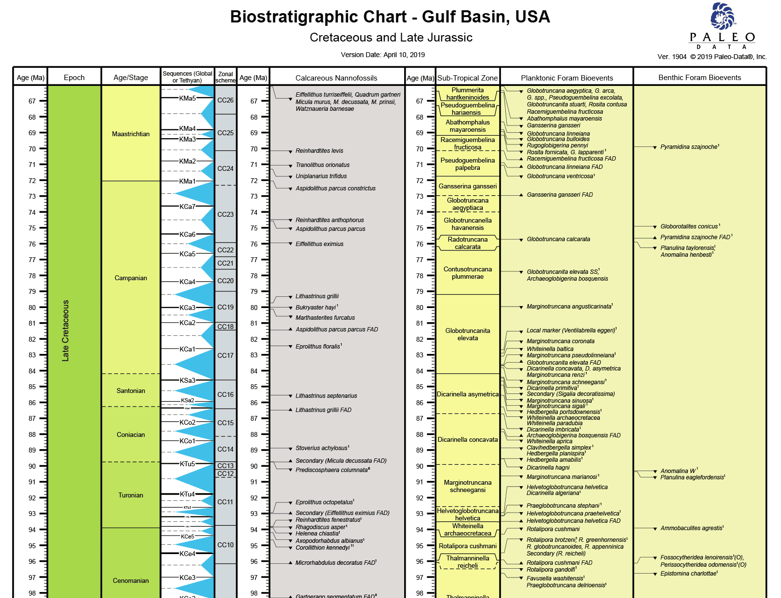
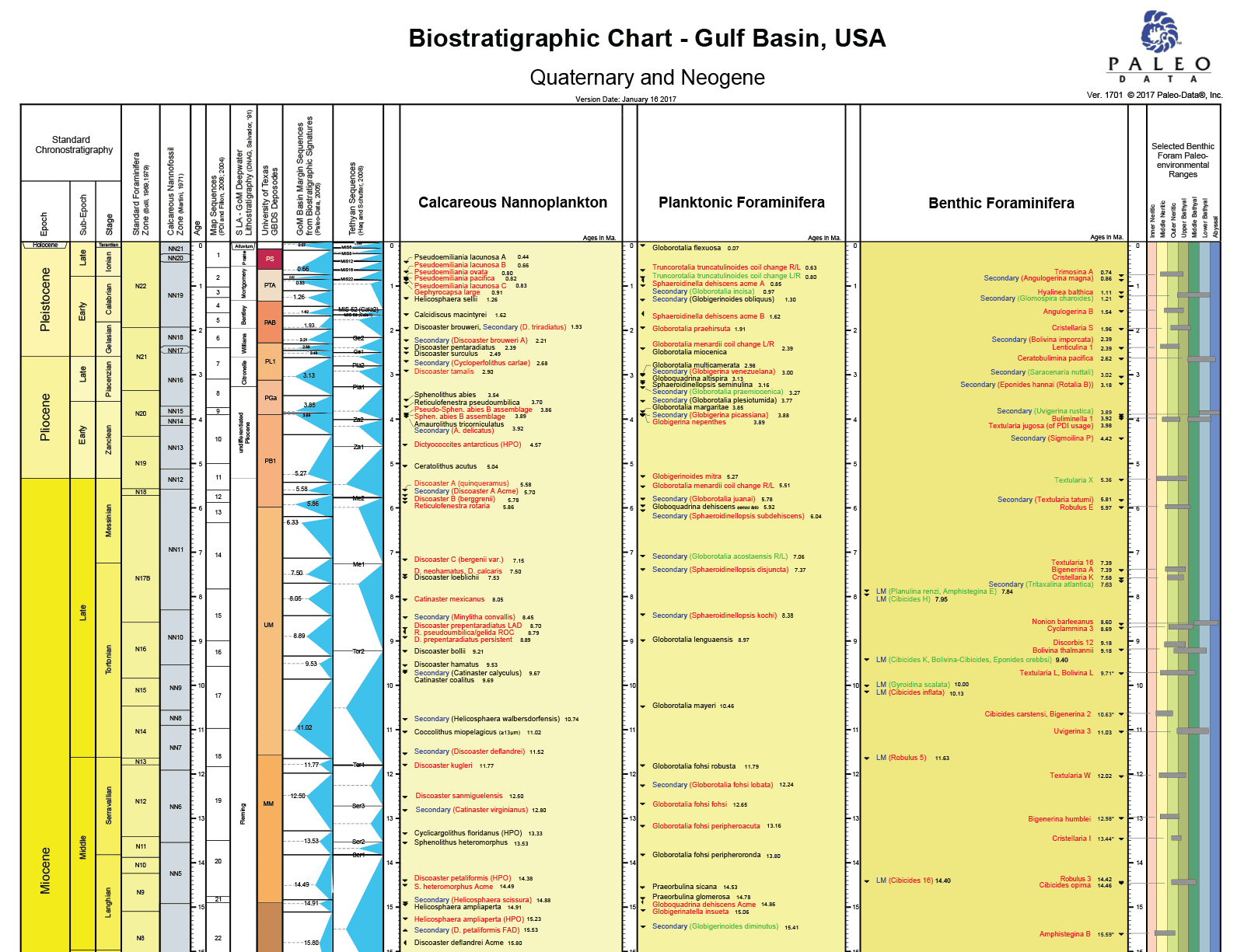
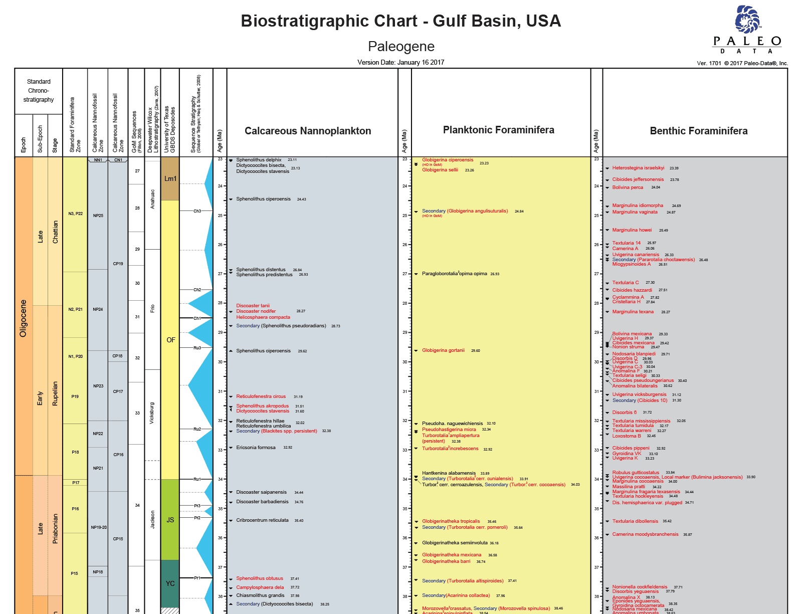
Free downloads – Biostratigraphic charts of the Gulf of Mexico and the Gulf Basin
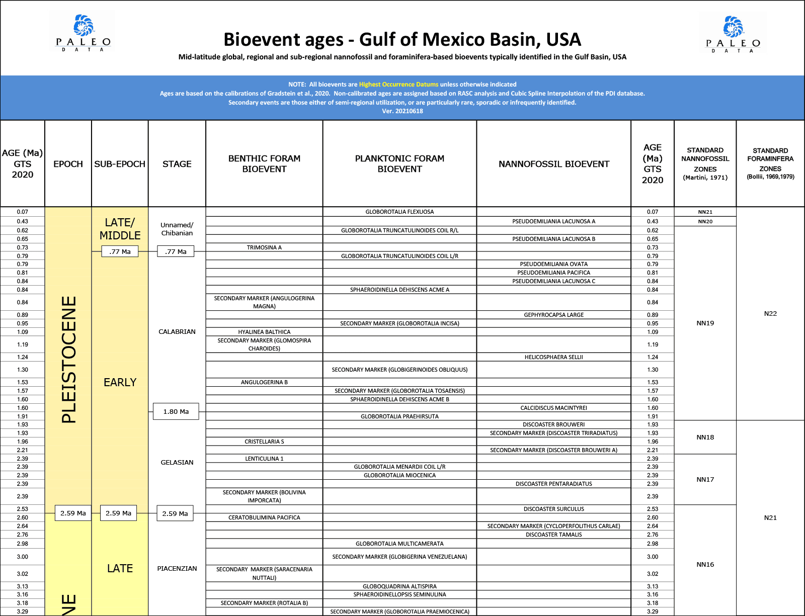
Bioevent ages – Gulf of Mexico Basin, USA
Mid-latitude global, regional and sub-regional nannofossil and foraminifera-based bioevents typically identified in the Gulf Basin, USA
Biostratigraphic Chart – Gulf Basin, USA
PetroStrat Connect – Providing Access to Paleo-Data datasets and reports
Please note that PetroStrat is transitioning away from MS-Access due Microsoft’s end of service in 2025. Customers who wish to continue receiving traditional updates in 2025 will be provided with a sharepoint link or hard media to the stand alone data files. These updates will be released on a near quarterly basis and specific to the current release (i.e., they will not include a complete of set of data or PDF reports from older releases).
For comprehensive updates, and to ensure ongoing support beyond 2025, PetroStrat Connect is highly recommended.

What is PetroStrat Connect?
PetroStrat Connect customers will be provided with access to the dedicated ‘PDI Module’ hosted on PetroStrat Connect, our new cloud-based subsurface characterisation and data delivery platform.
PetroStrat Connect is set to become an essential resource for exploration and development groups, providing essential data for correlation, seismic interpretation, basin analysis, geohistory reconstructions and reservoir continuity. Newly released well data is added throughout the year Consistent nomenclature and bioevent schemes are applied. Derivative maps including sequence-based accumulation rate, isopach, biofacies and age at TD are available as an option.
PetroStrat Connect is secure, using multifactor authentication (MFA) and Single-Sign-On (SSO) to authenticate users and keep you and your data safe on the platform. PetroStrat Connect aims to support your data management strategies by keeping all your licensed data in one central, easily accessible place. And we aim to help you interrogate your data quickly through our ecosystem of web applications that connect live to your dataset, providing mapping, correlation and charting tools direct in your web-browser.
Through PetroStrat Connect you will be able to:
- Access all ‘traditional’ Paleo-Data data quickly, directly in your web browser (no software installations needed) and download tabulated tops for the wells you need;
- All Paleo-Data releases will be automatically available to the user in PetroStrat Connect – no need for separate links to individual data releases;
- Improve your data management strategy by having all your available, released Paleo-Data datasets in a central, cloud-hosted environment accessible 24/7 by any internet-capable device anywhere (better performance with PC);
- Quickly correlate Paleo-Data’s US GoM Offshore Event tops and/or Ecozones directly on the PetroStrat Connect platform through a series of web-based applications;
- Quickly observe regional event and ecozone trends through geospatial interrogation, directly in your web browser;
- Access and download all available .PDF files associated with the GoM Offshore Database through a web-based map interface;
- Future roadmap improvements to the Connect platform on an annual subscription basis;
- This introductory offer includes 3 named users within your company domain;
- Licensees to the 2024 Fillon Geohistory Map Database will have access to shapefiles.

Reach out today
Please contact us for more information.